
Our Technology
TerraXAI builds a full environmental intelligence ecosystem that covers satellites, drones, IoT sensors, and advanced AI models. Our products work together to track wildfire risk, methane hotspots, land cover change, habitat conditions, and infrastructure exposure across wide regions. The platform supports decision-makers with real-time maps, alerts, and predictive analytics, while our sensor suite and drone units strengthen detection on the ground. With spatial AI agents and a powerful data engine, TerraXAI delivers fast, accurate, and actionable insight for industries, governments, and environmental teams.
.png)
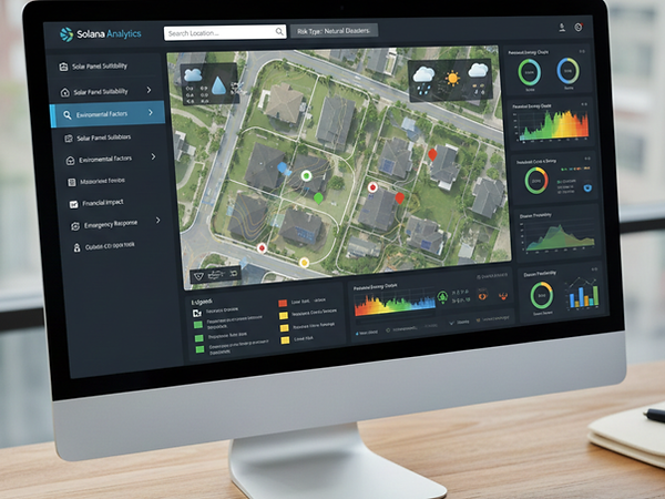
TerraXAI Energy Asset Monitoring
A geospatial intelligence solution that monitors environmental risk around energy infrastructure. By integrating satellite data, environmental indicators, and AI-driven analytics, the system supports asset protection, operational awareness, and resilience across energy facilities and surrounding landscapes.
.png)
.png)
.png)
.png)
.png)
.png)


.png)
.png)
.png)
.png)
Our Smart Technologies
TerraXAI Fire Risk Platform
TerraXAI delivers a full fire risk platform that helps teams across Canada see danger early and act fast. The system pulls data from satellites, drones, and ground sensors to reveal high-risk zones, spot early smoke, show the ignition point, and produce a clear spread forecast based on wind, topography, and fuel. It also produces burned-area maps and a recovery view that highlights vegetation stress and regrowth. All results appear in a simple dashboard that supports quick decisions for agencies, utilities, and communities.

.png)
TerraXAI Moose Collision Alert System
A real-time geospatial intelligence system that detects high-risk wildlife–vehicle interaction zones and delivers early alerts to support road safety. The platform integrates satellite data, environmental conditions, and AI models to reduce collision risk and improve transportation resilience in wildlife corridors.
TerraXAI Fire Spread Prediction Platform

TerraXAI provides a fast and reliable wildfire spread forecast that shows how a fire may move across the landscape under current conditions. The system uses wind direction, wind speed, fuel type, slope, and real surface moisture to map the most likely paths toward communities, roads, and infrastructure. Each forecast updates as new weather or sensor data arrives, so teams always see the freshest scenario. This feature supports safe evacuation plans, smarter resource placement, and stronger protection for forests and towns across Canada.

TerraXAI Moose Presence Probability WebGIS Platform
A web-based geospatial intelligence platform that maps moose presence probability using satellite data, environmental indicators, and AI-driven spatial models. The system supports habitat analysis, risk assessment, and planning by providing interactive, location-specific wildlife intelligence.
.png)
TerraXAI Real Time Hostpot Detection
TerraXAI Real time hotspot detection gives fast awareness of new fire starts across large regions. The system scans satellite feeds, 360 forest cameras, and ground sensors to spot heat or smoke the moment it appears. Each hotspot shows up on the map with clear location, confidence level, and nearby assets in danger. The platform updates as new data arrives, so teams always have the freshest view of early fire activity. This feature supports rapid response, early suppression, and safer protection for communities, forests, and infrastructure across Canada.